| 1.29 MB | |
| 2008-04-21 12:46:25 | |
 | |
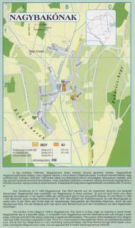
Nyilvános 2389 | 11148 | NAGYBAKÓNAK | A falu említése 1428-ban: Nagybakonok. Szláv eredetű, közszói jelentése: bükkös. Nagybakónak Nagykanizsától észak-keletre, szép völgyben fekszik, s ma is átszeli a Bakónaki-patak. A század második felében nagy erdőirtás folyt. A faluban 1925-ben 1400 ember lakott, mai lélekszáma 556 fő. A községben falumúzeum működik, ahol régi paraszti eszközök kerülnek bemutatásra. A falu közelében található a rendkívül érdekes természeti képződmény, a Kőszikla-szurdok, melyen turista út vezet keresztül. A településről turista úton megközelíthető a dombtetőn álló TV-torony is. Ihre Erwähnung ist in 1428 Nagybakonok. Das Wort stammt aus der slawischen Sprache und bedeutet Buchenwald. Nagybakónak liegt nordöstlich von Nagykanizsa in einem schönen Tal und ist auch heute vom Bach Bakónaki durchgequert. In der zweiten Hälfte des Jahrhunderts gab es hier eine große Rodung. Im Dorf lebten in 1925 1.400 Menschen, seine heutige Einwohnerzahl ist 556. Hier existiert ein Freilichtmuseum, wo alte Bauerngeräte zu sehen sind. In der Nähe des Dorfes liegt ein interessantes Naturgebilde die Steinfelsen-Klammen, durch die eine Wanderroute führt. Von der Siedlung kann man durch eine Wanderroute auch den Fernsehturm auf dem Hügelrücken besichtigen. The mention of the village in 1428 is Nagybakonok. The name is of Slav origin, its meaning is beech forest. Nagybakónak lies in a beautiful valley, in norteastern from Nagykanizsa and the Bakónaki-brook cuts through it even today. In the second half of this century there was a significant deforestation. The number of the inhabitants in the village in 1925 was 1400, the today\'s population is 556. There is a rural museum in the settlement where are exhibited old peasant tools. Not far from the village there is a very interesting natural formation, the Rock-Ravine through which leads a tour-route. Leaving the village on a tour-route you can approach the TV-tower standing at the top of the hill. A részlet a következő kiadványból származik/Die Teile stammen vom volgenden Buch/This text came from the following book: Cím/Titel/Title: Zala megye településeinek atlasza - 257 település részletes térképe/Atlas der Komitat Zala - 257 Detailte Siedlungskarten/Zala county\'s Atlas - 257 settlement maps. Közreműködő/contributor: Lackner László (1943) (fotó) Kiadás/Ausgabe/Publisher: Gyula : HISZI-MAP, 1997 Sorozat/Serie/Series: Indulástól - megérkezésig... ETO: 912(439.121-2) ; 908.439.121 Cutter: Z 19 ISBN: 963-610-025-4 Oldalszám/Seiten/Pages: 323, 81 p. Megjegyzés/Note: Lezárva/Abgeschlossen am/Closed am: 1997. máj. 30. |
